U.S. Immigrant Population by State and County
U.S. Immigrant Population by State and County
This map displays the geographic distribution of immigrants in the United States by country of origin. Hover over a state to get the total foreign-born population and double click on a state to get top county estimates. Use the dropdown menu under the map to select a particular country or region of origin. To deselect, click outside the U.S. map. When a state is selected, counties within the state are ranked. (By default, the initial view shows a list of top counties for the entire United States). To return to the original view, click the home icon on the left. And for Alaska, first zoom out the map view (click the minus sign).
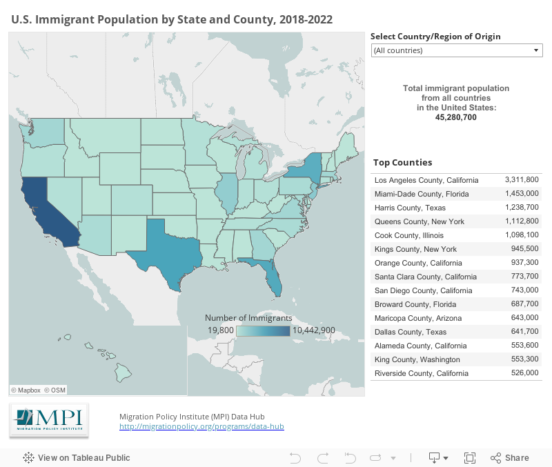
1) The term "immigrant" (or "foreign born") refers to people residing in the United States who were not U.S. citizens at birth. This population includes naturalized citizens, lawful permanent residents (LPRs), certain legal nonimmigrants (e.g., persons on student or work visas), those admitted under refugee or asylee status, and persons illegally residing in the United States.
2) Population estimates for states and counties with an immigrant population under 2,000 are not provided due to insufficient sample size.
3) Estimates for the Middle East in the “MENA: Middle East and North Africa” region are based on the following geographies: Northern Africa as well as Iraq, Jordan, Kuwait, Lebanon, Saudi Arabia, Syria, United Arab Emirates, Yemen, and “Other” Western Asia.
4) From 2022 on, the U.S. Census Bureau ACS data for Connecticut are shown by “planning regions,” instead of counties. Read more about the request to switch to nine planning regions used as county-equivalent geographic units here.
Migration Policy Institute tabulation of data from the U.S. Census Bureau's pooled 2018-2022 American Community Survey.