

Mapping West Africa's Migration and Land-Management Crisis
Environmental changes — both natural and manmade — have long been a primary driver of migration in West Africa, one of the world's most mobile regions. Short- and long-term migrants cope with cyclical drought and desertification by settling areas with a more favorable climate and exploitable or arable land. Migration-driven population growth in these limited areas — including along the periphery of what is known as the "W" Region Transboundary Biosphere Reserve, a protected international park in West Africa — has produced a land-management crisis with important social, ecological, and economic implications both locally and regionally.
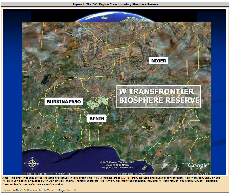
Seasonal drought in the northern region of the park, known as WTBR or the W Transborder Park, continually pushes local populations southward along its periphery, impacting land-use practices and threatening environmental conservation and biodiversity throughout the region. The first internationally recognized transboundary biosphere reserve in Africa, the WTBR spans about 12,000 square miles in Benin, Burkina Faso, and Niger. Its name refers to the double meander, similar to a "W," created by the Niger River in the northeast area of the reserve (see Figure 1).
Land is the most important resource in the region as it is the basis for all productive activities — from subsistence farming using traditional techniques (to grow crops such as grains and vegetables) and small-scale livestock raising to financial speculation on cotton production. There are also numerous local, national, and international actors with overlapping and competing interests with regard to the WTBR. Traditional farmers who exploit small fields for family production in certain zones compete with animal breeders and seasonal migrants looking for pastures for their cattle. Financial speculators invest in large strips of land for cotton production toward the exterior of the park — a practice which, despite government support in Benin and Burkina Faso, can have devastating environmental and economic impacts well beyond the cotton fields themselves. International and regional actors also have taken an interest in the WTBR for a variety of environmental and economic reasons.
This article examines migration and land-management challenges in the WTBR through the use of reflexive maps, which capture data not only about migrants' paths, long- or short-term projects, and ethnic groups, but also about the social values and knowledge that they carry with them. It argues that reflexive maps provide information that is useful for adequate land management in West Africa as well as rural contexts worldwide. The article is based on field research conducted by the Diathesis Cartographic Lab team of the University of Bergamo in a European Union-led (EU) conservation and local development project called the Regional "W" Park Program/ECOPAS (Protected Areas of Sahelian Africa).
The "W" Region Transboundary Biosphere Reserve
The WTBR began as a smaller territory comprised of inhabited forests designated by the French government in the mid-1920s as the first refuge park in West Africa. French colonialists later expanded and territorially delineated the area as a national park in 1954.
After a long period of abandonment, the area gained renewed international attention in 1996 when United Nations Educational, Scientific, and Cultural Organization (UNESCO) designated the "W" Region Park of Niger (part of the modern-day WTBR) as a biosphere reserve. Revitalization began in the early 2000s through an EU-led project and international agreement (under the Lomé Convention, a trade and aid agreement concluded in 1975) between the European Union and Benin, Burkina Faso, and Niger. The initiative to revive the park aimed to reinforce regional and international cooperation on conservation and local development with the participation of local communities.
Because of the area's rich biodiversity, UNESCO in 2002 recognized a larger stretch of land encompassing the "W" Region Park of Niger, as well as parts of neighboring Benin and Burkina Faso, as the modern-day "W" Region Transboundary Biosphere Reserve. Although there were already five transboundary biosphere reserves in Europe at the time, the WTBR was the first in Africa; today, there are 13 worldwide.
As is often the case with other territories recognized as biosphere reserves, funds began pouring into the WTBR from the European Union, the World Bank, and other international bodies interested in heading up projects for sustainable development in the region. The WTBR has also been referred to as a "peace park" which carries significant political importance because it spans countries that have been or are in conflict (e.g. the ongoing Tuareg conflict and national border disputes).
Today one of West Africa's largest protected areas, the WTBR has a densely inhabited periphery, especially in the south and along the highly fertile northeastern border area between Benin and Niger created by the Niger River (see Figure 2). The WTBR is comprised of three different zones: the core area, the buffer zone, and the transition area. Each zone has a different level of protection, although boundaries between them are sometimes unclear.
In the core area, productive activities such as farming, hunting, or cattle herding are prohibited, but there are small roads to allow for tourism (limited to animal watching from a distance). Although in theory no one may reside in the core area, there have been reports of conflict between park rangers and people attempting to settle or practice productive activities there. In the buffer zone, some controlled agricultural practices are allowed such as small-scale farming. Cotton fields in this zone often stretch into — and cause damage in — what is considered to be the core area, as well as into peripheral areas. There are mixed levels of protection in the outermost transition zone, and permanent settlement as well as productive activities are allowed in many areas.
Colonialism and the Complexities of Land Claims
The 1884 Berlin conference — which brought together officials of several European colonial powers and the United States to redesign the geopolitical borders of Africa — is one of the main sources of complexity in West African society today. Niger, Burkina Faso (formerly French Upper Volta), and Benin (formerly French Dahomey), whose territories are part of the WTBR, were all French colonies within West Africa from roughly the end of the 19th century to 1960.
During the colonial era, France exploited the region's bountiful natural resources, designating many "classified forests" (protected areas). The political campaign of territorial domination was supplemented by a large presence of settlers from metropolitan France as well as a variety of political, educational, and religious initiatives driven by the French colonial rationale of mission civilisatrice, or mission to "civilize" the local populations. These efforts permeated nearly every sector of West Africans' daily lives, forever altering socioeconomic development, cultural traditions, religious convictions, language, and local and national economy and governance. In addition, French colonial leaders often resorted to divide-and-conquer strategies to weaken resistance from local ethnic groups, treating some favorably while undermining others.
Most importantly, the international borders that were drawn at the onset of the colonial era — without regard for pre-existing ethnic boundaries and migration dynamics — remained in place. Today, these boundaries coexist with much difficulty alongside a traditional political system based on ethnicity dating back many centuries ago. As a result, two different sets of "borders" exist: one that is clearly delineated according to international norms, and the other which is implicit and substantiated by everyday dealings on the ground.
This duality on land claims has produced coexisting yet contradictory sets of land-management regulations. The first set of rules exists in written form (in administrative records) and is based on individual registration of land property. The second one, which exists only orally, collectively organizes access to land based on internal affairs involving traditional networks and land loans. Land is not traditionally viewed as an individual property that can be bought and sold between individuals. Instead, it is a collective asset that a land chief manages, balancing the needs of new short- and long-term migrants with the will of the village at large.
Migration and the Land-Management Crisis in West Africa

Societal Impacts of Migration in the WTBR Periphery
International migration substantially impacts the everyday lives of inhabitants of the WTBR periphery, their land-use practices, and the local and national economy. Long-term migration flows increase in volume when agricultural and environmental crises persist, forcing residents (usually entire families) to abandon their villages and settle for long periods in another area. Experienced migrants often choose areas with which they are already familiar from a previous migration.
Among the approximately 650,000 inhabitants along the WTBR periphery, there are ten main ethnic groups: the Batonou, Mokollé, Gando, and Dendi in Benin; the Gourmantché in Burkina Faso; the Djerma, Hausa, Foulmangani, and Bella in Niger; and the Peul in all three countries. Until recently, all were well known for their strong territoriality. Some ethnic groups are migratory, such as the Hausa and Djerma from northern areas of the park, while others play the role of receiving society, including the Batonou, Mokollé, Dendi, and Gourmantché (see Figure 2). Djerma and Hausa engage in both long- and short-term migration.
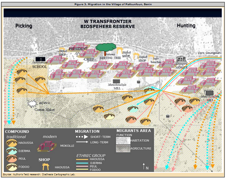
As in the example of the village of Fiafounfoun, located in the northern region of Benin, migrants settle in decentralized areas, creating settlements and choosing a chief from among their group through whom they will address their requests for land loans (see Figure 3). The chief is also a religious referent, usually a Muslim imam since migrants often come from the more Islamized northern regions (especially in Niger).
Some areas of land in the WTBR periphery become saturated when the inflow of new settlers is sustained for long periods of time. According to traditional norms of hospitality throughout the region, residents must welcome all new migrants and, if needed, share their land with them for subsistence. Because land is a limited natural resource, land chiefs have less and less land to loan to newcomers as the population increases. Land loans provide the basis of new migrants' integration into the host community, but can also lead to tensions with local residents and other migrants.
The movement of people also alters villages' geographies, sometimes creating whole new villages or causing them to disappear when abandoned. Migrants introduce new land-use practices and experiment with new agricultural or commercial crops and activities where they settle.
Cotton Production
Reliant on a large local workforce to remain competitive despite fluctuations in the world market, cotton production has expanded in many areas where migrant inflows are significant. International recognition of the WTBR has prompted greater regional efforts to protect its natural resources, but the governments of Benin and Burkina Faso — while simultaneously expressing concern about environmental conservation — have shown interest in expanding cotton production. In addition to causing pollution, cotton production compels farmers to cultivate their crops individually, thus undermining centuries-old land-use practices. Traditional and collective knowledge and values are dominated by individual interests, modern chemical farming techniques, and the logic of profit maximization.
Future Perspectives
Increasing settlement along the periphery places a strain on the WTBR's already limited natural resources. Migration has also often destabilized the traditional socioterritorial organization of periphery villages — new actors are introduced into the land-management system, and access to land becomes increasingly rare.
While the WTBR may serve as a context for reinforcing regional cooperation on sustainable development and regional political stability, migration in the WTBR periphery creates local and regional territorial dynamics that are inadequately managed. A shared project among the three countries to improve and harmonize land management could be pursued to strike a better balance between countering environmental changes, preserving natural resources, and meeting the needs of local populations.
For more information, see: Ghisalberti, Alessandra. Le migrazioni in Africa Occidentale tra ambiente e politica. La periferia del Parco Regionale W (Benin, Burkina Faso, Niger). Turin: L'Harmattan Italia.
Sources
Adepoju Aderanti. 2005. Migration in West Africa. Lagos: Global Commission on International Migration. Available online.
Amin, Samir. (ed.). 1974. Modern Migrations in Western Africa : Studies Presented and Discussed at the Eleventh International African Seminar, Dakar, April 1972. London: Oxford University Press.
Michel, Benoit. 1999. Statut et usages du sol en périphérie du Parc National du "W" du Niger. Paris/Niamey: Institut de recherche pour le développement. Available online.
Bossard, Laurent. 2009. The Future of International Migration to OECD Countries Regional Note West Africa. Paris: Organization for Economic Cooperation and Development. Available online.
Casti, Emanuela. 2006. Geografia e partecipazione: la Strategia SIGAP (sistemi informativi geografici per le aree protette) nella Riserva della Biosfera Transfrontaliera "W" (Africa Occidentale), in Bollettino della Società Geografica Italiana 12 (11): 949-975. Available online.
Casti, Emanuela and S. Yonkeu S. 2009. Le Parc National d'Arly et la falaise du Gobangou. Paris: L'Harmattan.
Alpha Gado, Boureima. 1993. Une histoire des famines au Sahel. Etude des grandes crises alimentaires (XIXe-XXe siècles). Paris: L'Harmattan.
Onwuka, R. I. 1982. The ECOWAS Protocol on the Free Movement of Persons: A Threat to Nigerian Security? in African Affairs 81 (323): 193-206.
Rouch Jean. 1956. Migrations en Gold Coast. Paris: Centre National de la Recherche Scientifique.
United Nations Educational, Scientific, and Cultural Organization (UNESCO). 2002. Biosphere Reserves: Special Places for People and Nature. Paris: UNESCO. Available online.
--. 2003. Five Transboundary Biosphere Reserves in Europe, Technical notes. Man and Biosphere Program. Paris: UNESCO. Available online.
--. The Man and Biosphere Reserve Program. Biosphere Reserve Information: 'W' Region. Available online.